P.O Box 02, Karuguuza| Tel: +256-772-361860| E-mail: [email protected] | [email protected]
Kibaale: Geographical Features
Topography
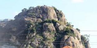
Kibaale district is part of the central plateau with an altitudinal range of about 2000-4000 ft. above sea level. The hilly and rocky relief presents challenges during construction and maintenance of roads and buildings and also makes agricultural production difficult like through inducing soil erosion.
Climate
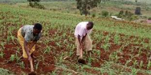
Kibaale district has favourable climate. It enjoys a bi-modal rainfall type which varies between 1000 mm -1500 mm per annum that is moderate to high rainfall. Rainfall comes in two peaks; one from March to May and the second from September to December. However, the western part of the district bordering the rift valley is dry. Temperatures are relatively high varying between 15 degrees Celsius to 30 degrees Celsius. The bi-modal type of rainfall is conducive for rain fed agricultural production throughout the year and crops mainly grown include bananas, tobacco, coffee, maize, beans and tea. Upland rice and cocoa are increasingly gaining importance in the district.
The process of erosion and accumulation that acted upon the land surfaces gave rise to several types of soils in Kibaale District. The soils of the district are of ferrallitic type. Productivity of these soils largely depends on favourable rainfall. Adequate depth and maintenance of the humic top soil. There are basically 3 soil mapping units in Kibaale district namely; Buwekula Catena, Buyaga Catena and Kamusenene series. Buwekula catena covers 90% of Buyanja County and comprises three major types of granitic soils namely; Shallow loams, red clay loams and brown gravelly clay loams. Shallow loams have Moderate acidity with moderate productivity and mainly support the growing of tobacco and tea.
Vegetation
There are three broad categories of vegetation in the district namely; the modified equatorial type, the wooded savannah mosaic and savannah grassland. The modified equatorial vegetation covers a greater part of the district especially in the sub counties of Bwamiramira, Kyebando, and Nyamarwa. This type of vegetation used to be equatorial in nature but has been modified as a result of human activity. The wooded savannah mosaic covers a greater part of the district and forms a transitional zone from the modified equatorial vegetation to open savannah grassland as commonly observed in the sub counties of Matale, Nyamarwa and parts of Nyamarunda. The thick forests especially those on private land are being used for timber harvesting although this poses a threat of environmental degradation since reforestation and afforestation are very limited. The relative price of timber and its products in the district is low compared to other districts and the district is a major source of timber to the Kampala market.
Wednesday, April 4, 2018